Fail:Iran-CIA WFB Map.png
No higher resolution available.
Iran-CIA_WFB_Map.png (332 × 353 pixels, file size: 14 KB, MIME type: image/png)
\behbahan
Liklik toksave bilong senis
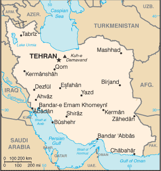
| Description | Map of Iran showing major cities. | |||
| Date | ||||
| Source | CIA, The World Factbook, 2004 | |||
| Author | CIA | |||
| Permission (Reusing this file) |
|

Ol senis bilong dispela fail
Click on a date/time to view the file as it appeared at that time.
| De/Taim | Liklik | Ol sais | Yusa | Tingting | |
|---|---|---|---|---|---|
| bilong nau | 09:14, 27 Mas 2005 | | 332 × 353 (14 KB) | Wolfman~commonswiki | {{CIA-map}} |
Ol fail link
Dispela pes i link long dispela fail:
Global file usage
The following other wikis use this file:
- Usage on af.wikipedia.org
- Usage on ar.wikipedia.org
- Usage on ary.wikipedia.org
- Usage on bn.wikipedia.org
- Usage on bs.wikipedia.org
- Usage on ca.wikipedia.org
- Usage on de.wikipedia.org
- Usage on en.wikipedia.org
- Usage on en.wikisource.org
- Usage on fa.wikipedia.org
- Usage on fi.wikipedia.org
- Usage on hi.wikipedia.org
- Usage on hr.wikipedia.org
- Usage on hu.wikipedia.org
- Usage on hu.wiktionary.org
- Usage on ilo.wikipedia.org
- Usage on incubator.wikimedia.org
- Usage on io.wikipedia.org
- Usage on it.wikipedia.org
- Usage on ja.wikipedia.org
- Usage on mi.wikipedia.org
View more global usage of this file.